Stock media library
Royalty-free stock clips for every story
Search travel, city, drone and B-roll footage, preview each clip, and download in HD or 4K. Browsing is open to everyone — sign in only when you want to download.
 Video
Video Canada, Australia, Brazil Map Animation — light globe 16:9
A 7-second 1080p 16:9 animated map video rendered on a globe with light styling over Africa. It highlights Canada, Australia, Brazil, and Morocco with glow emphasis. Basemap: no labels. Suitable for broadcast, presentations, explainers, and digital media.
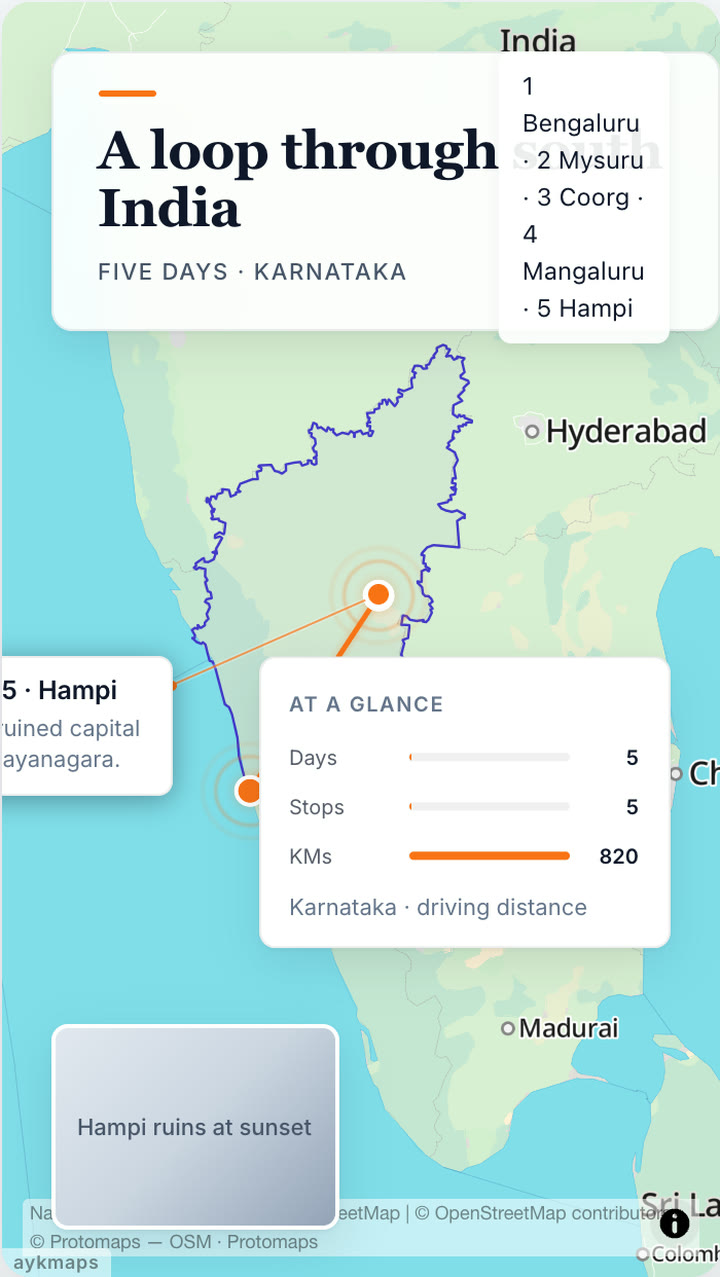
Video Flight path Map Animation — light flat map 16:9
A 8-second 1080p 16:9 animated map video rendered on a flat map with light styling over South Asia. A flight path travels from Point 1 to Point 2 (plane marker and road route (driving)). The camera uses a custom camera path. Basemap: 3D buildings. Suitable for broadcast, presentations, explainers, and digital media.
Video Continent Map Animation — navigation night 16:9
An animated map video rendered on a globe using navigation night styling. Duration: 5-second. Suitable for broadcast, presentations, and digital media.
Video Flight Path Animation — 2 Waypoints over Middle East | globe 16:9
A 9-second animated flight path video tracing a route across 2 waypoints over Middle East on a globe with street map styling. The flight path is rendered in a dashed line style. Camera follows the route with a none effect, creating a dynamic aerial journey visualization. Perfect for airline route maps, logistics explainers, travel vlogs, military route animations, delivery tracking visuals, and geographic storytelling content.
Video Flight Path Animation — 5 Waypoints over North America | globe 9:16
A 15-second animated flight path video tracing a route across 5 waypoints over North America on a globe with dark minimal styling. The flight path is rendered in a gradient line style. Camera follows the route with a follow effect, creating a dynamic aerial journey visualization. Perfect for airline route maps, logistics explainers, travel vlogs, military route animations, delivery tracking visuals, and geographic storytelling content.
Video Continent Map Animation — street map 9:16
An animated map video rendered on a globe using street map styling. Duration: 5-second. Suitable for broadcast, presentations, and digital media.
Video Flight Path Animation — 4 Waypoints over Africa | globe 16:9
A 30-second animated flight path video tracing a route across 4 waypoints over Africa on a globe with light minimal styling. The flight path is rendered in a dashed line style. Camera follows the route with a follow effect, creating a dynamic aerial journey visualization. Perfect for airline route maps, logistics explainers, travel vlogs, military route animations, delivery tracking visuals, and geographic storytelling content.
Video Flight Path Animation — 6 Waypoints over Western Europe | globe 16:9
A 30-second animated flight path video tracing a route across 6 waypoints over Western Europe on a globe with satellite with streets styling. The flight path is rendered in a dotted line style. Camera follows the route with a follow effect, creating a dynamic aerial journey visualization. Perfect for airline route maps, logistics explainers, travel vlogs, military route animations, delivery tracking visuals, and geographic storytelling content.
Video India Map Animation — globe dark minimal 9:16
A smooth 6-second animated map video showcasing India on a globe with dark minimal styling. The country border is highlighted with a solid fill at 55% opacity. The camera uses a follow movement effect. Ideal for news broadcasts, documentaries, travel content, geography explainers, and educational presentations about India and the surrounding region.
Video Flight Path Animation — 4 Waypoints over North America | globe 9:16
A 6-second animated flight path video tracing a route across 4 waypoints over North America on a globe with dark minimal styling. The flight path is rendered in a gradient line style. Camera follows the route with a follow effect, creating a dynamic aerial journey visualization. Perfect for airline route maps, logistics explainers, travel vlogs, military route animations, delivery tracking visuals, and geographic storytelling content.
Video Flight Path Animation — 4 Waypoints over Central and East Asia | globe 9:16
A 6-second animated flight path video tracing a route across 4 waypoints over Central and East Asia on a globe with dark minimal styling. The flight path is rendered in a gradient line style. Camera follows the route with a follow effect, creating a dynamic aerial journey visualization. Perfect for airline route maps, logistics explainers, travel vlogs, military route animations, delivery tracking visuals, and geographic storytelling content.
Video Flight Path Animation — 4 Waypoints over Central and East Asia | globe 9:16
A 9-second animated flight path video tracing a route across 4 waypoints over Central and East Asia on a globe with street map styling. The flight path is rendered in a dashed line style. Camera follows the route with a follow effect, creating a dynamic aerial journey visualization. Perfect for airline route maps, logistics explainers, travel vlogs, military route animations, delivery tracking visuals, and geographic storytelling content.
Video Flight Path Animation — 4 Waypoints over Central and East Asia | globe 9:16
A 6-second animated flight path video tracing a route across 4 waypoints over Central and East Asia on a globe with dark minimal styling. The flight path is rendered in a gradient line style. Camera follows the route with a Follow effect, creating a dynamic aerial journey visualization. Perfect for airline route maps, logistics explainers, travel vlogs, military route animations, delivery tracking visuals, and geographic storytelling content.
Video Flight Path Animation — 4 Waypoints over North America | globe 9:16
A 6-second animated flight path video tracing a route across 4 waypoints over North America on a globe with dark minimal styling. The flight path is rendered in a gradient line style. Camera follows the route with a Follow effect, creating a dynamic aerial journey visualization. Perfect for airline route maps, logistics explainers, travel vlogs, military route animations, delivery tracking visuals, and geographic storytelling content.
Video India Map Animation — globe dark minimal 9:16
A smooth 6-second animated map video showcasing India on a globe with dark minimal styling. The country border is outlined with a solid fill at 55% opacity. The camera uses a Follow movement effect. Ideal for news broadcasts, documentaries, travel content, geography explainers, and educational presentations about India and the surrounding region.
Video India Map Animation — globe street map 9:16
A smooth 8-second animated map video showcasing India on a globe with street map styling. The country border is outlined with a solid fill at 35% opacity. The camera uses a Static movement effect. Ideal for news broadcasts, documentaries, travel content, geography explainers, and educational presentations about India and the surrounding region.
Video Flight Path Animation — 4 Waypoints over North America | globe 9:16
A 8-second animated flight path video tracing a route across 4 waypoints over North America on a globe with street map styling. The flight path is rendered in a solid line style. Camera follows the route with a Static effect, creating a dynamic aerial journey visualization. Perfect for airline route maps, logistics explainers, travel vlogs, military route animations, delivery tracking visuals, and geographic storytelling content.
Video Flight Path Animation — 4 Waypoints over Central and East Asia | globe 9:16
A 8-second animated flight path video tracing a route across 4 waypoints over Central and East Asia on a globe with street map styling. The flight path is rendered in a solid line style. Camera follows the route with a Static effect, creating a dynamic aerial journey visualization. Perfect for airline route maps, logistics explainers, travel vlogs, military route animations, delivery tracking visuals, and geographic storytelling content.
Video Flight Path Animation — 2 Waypoints over Africa | globe 16:9
A 10-second animated flight path video tracing a route across 2 waypoints over Africa on a globe with street map styling. The flight path is rendered in a dashed line style. Camera follows the route with a none effect, creating a dynamic aerial journey visualization. Perfect for airline route maps, logistics explainers, travel vlogs, military route animations, delivery tracking visuals, and geographic storytelling content.
Video China Map Animation — flat map street map 16:9
A smooth 5-second animated map video showcasing China on a flat map with street map styling. The country border is highlighted with a solid fill at 20% opacity. The camera uses a none movement effect. Ideal for news broadcasts, documentaries, travel content, geography explainers, and educational presentations about China and the surrounding region.
Video Map Map Animation — custom style 16:9
An animated map video rendered on a flat map using custom style styling. Duration: 5-second. Suitable for broadcast, presentations, and digital media.
Video Iran Map Animation — flat map satellite 16:9
A smooth 5-second animated map video showcasing Iran on a flat map with satellite styling. The country border is highlighted with a solid fill at 85% opacity. The camera uses a zoom_in movement effect. Ideal for news broadcasts, documentaries, travel content, geography explainers, and educational presentations about Iran and the surrounding region.
Video Iran Map Animation — flat map satellite 16:9
A smooth 5-second animated map video showcasing Iran on a flat map with satellite styling. The country border is highlighted with a solid fill at 90% opacity. The camera uses a zoom_in movement effect. Ideal for news broadcasts, documentaries, travel content, geography explainers, and educational presentations about Iran and the surrounding region.
Video Iran Map Animation — globe street map 16:9
A smooth 5-second animated map video showcasing Iran on a globe with street map styling. The country border is highlighted with a solid fill at 20% opacity. The camera uses a none movement effect. Ideal for news broadcasts, documentaries, travel content, geography explainers, and educational presentations about Iran and the surrounding region.
Video Iran Map Animation — globe satellite 16:9
A smooth 5-second animated map video showcasing Iran on a globe with satellite styling. The country border is highlighted with a solid fill at 75% opacity. The camera uses a pan_left movement effect. Ideal for news broadcasts, documentaries, travel content, geography explainers, and educational presentations about Iran and the surrounding region.
Video Flight Path Animation — 4 Waypoints over Middle East | globe 16:9
A 8-second animated flight path video tracing a route across 4 waypoints over Middle East on a globe with street map styling. The flight path is rendered in a dashed line style. Camera follows the route with a none effect, creating a dynamic aerial journey visualization. Perfect for airline route maps, logistics explainers, travel vlogs, military route animations, delivery tracking visuals, and geographic storytelling content.
Video India Map Animation — globe street map 16:9
A smooth 5-second animated map video showcasing India on a globe with street map styling. The country border is highlighted with a solid fill at 55% opacity. The camera uses a fly_in movement effect. Ideal for news broadcasts, documentaries, travel content, geography explainers, and educational presentations about India and the surrounding region.
Video Flight Path Animation — 10 Waypoints over Middle East | globe 16:9
A 13-second animated flight path video tracing a route across 10 waypoints over Middle East on a globe with satellite with streets styling. The flight path is rendered in a dashed line style. Camera follows the route with a follow effect, creating a dynamic aerial journey visualization. Perfect for airline route maps, logistics explainers, travel vlogs, military route animations, delivery tracking visuals, and geographic storytelling content.
Video Flight Path Animation — 8 Waypoints over Middle East | globe 16:9
A 12-second animated flight path video tracing a route across 8 waypoints over Middle East on a globe with street map styling. The flight path is rendered in a dashed line style. Camera follows the route with a zoom_out effect, creating a dynamic aerial journey visualization. Perfect for airline route maps, logistics explainers, travel vlogs, military route animations, delivery tracking visuals, and geographic storytelling content.
Video Flight Path Animation — 10 Waypoints over Africa | globe 16:9
A 30-second animated flight path video tracing a route across 10 waypoints over Africa on a globe with street map styling. The flight path is rendered in a dotted line style. Camera follows the route with a follow effect, creating a dynamic aerial journey visualization. Perfect for airline route maps, logistics explainers, travel vlogs, military route animations, delivery tracking visuals, and geographic storytelling content.
Video Flight Path Animation — 9 Waypoints over Africa | flat map 16:9
A 30-second animated flight path video tracing a route across 9 waypoints over Africa on a flat map with street map styling. The flight path is rendered in a dotted line style. Camera follows the route with a pan_right effect, creating a dynamic aerial journey visualization. Perfect for airline route maps, logistics explainers, travel vlogs, military route animations, delivery tracking visuals, and geographic storytelling content.
Video India Map Animation — globe street map 9:16
A smooth 5-second animated map video showcasing India on a globe with street map styling. The country border is highlighted with a solid fill at 100% opacity. The camera uses a zoom_in movement effect. Ideal for news broadcasts, documentaries, travel content, geography explainers, and educational presentations about India and the surrounding region.
No clips match your search. Try a different term.